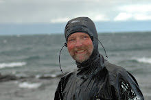
 Dress for immersion is the mantra of the Lake Superior paddler. If you are expecting me to rip the young lady in the image above you are wrong. On that particular day the water temp at Little Sand Bay, where the image was taken, was in the 70F range. I'm going to ignore the lack of a spray skirt and the life jacket bungeed on the front deck for now. If you look closely at the lead image from the last post you will see her paddling off along the shore as we middle aged warriors in our Hydroskin, neoprene, and even a stray dry suit, prepare to launch for some island hopping. Many of us actually went swimming that same day on the Raspberry spit and not just for a quick dip. It was luxurious floating and swimming in the balmy water after stripping off the malodorous neoprene that we all wore out of force of habit on the big lake. The question however, is how do we know what the water temperature is on Gitchee Gummee and what it will be in a few hours or the next day?
I made a little change in how the links on the right of the blog page are organized. I broke out the Lake Superior resources and called it trip planning. The realtime wave height, nearshore, mainland sea caves wave tool, and mid lake and Devils Island weather stations are all in one convenient spot. So is the critical real time satellite water temp chart. On the day we launched the wind was minimal and the water temp all around the islands was consistently in the high 60's to low 70'sF. That was not the case this morning. Click on the water temp map below and take a closer look.

The wild card on Lake Superior is the wind. In a 1,300' deep lake with a summer that pretty much goes from the 4th of July until Labor Day, there is always cold water lurking around somewhere. Its the wind that can move it to where its least expected. On shore winds typically blow warm surface water into bowl shaped bays and other sheltered areas and there is some mighty fine swimming in the waters around the Apostles this time of year. Look closely at the image above. I know, I know, the map sucks with missing and misplaced islands but we all can get the general idea. That warm water is still around in the Stockton Island area and deeper into Chequamagon Bay. But look at Point Detour at the tip of the Bayfield peninsula. Roughly two miles apart we see 48F water and 65F water. Check out that 36F off the north end of Sand Island. Off shore winds blow that warm water out into the lake and the colder, deeper stuff wells up. A rough gauge of what to wear on the water has been the Rule of 120. This states that if the combination of the air and water temperature (Fahrenheit) is over 120 you should be good without protective gear. This satellite image pretty much debunks that theory. It's been in the mid 80's recently. If a person went over off Pt Detour today, the rule of 120 would say you are good; 80F + 48F = 128. If you go over in 48F water and aren't wearing a wet or dry suit however, you can kiss your ass goodbye in a relatively short time. How long of a time? In 30-60 minutes you would be unconscious and in under 3 hours you are deceased.
Our attractive paddler above was good to go last Sunday. Today she is risking her life, especially because there was no paddle float or bilge pump to be seen. This time of year I would have to say a paddler needs a minimum of Hydroskin gear. I paddled solo back to LSB from the Bear Spit on Monday after wishing the rest of the Tri State paddlers the best of luck. The day before with 9 other paddlers I had my Hydroskin on. For the solo trip I had on the shorty wetsuit. I had a radio, phone, map, gps, and a pretty decent roll. The air and water were warm. In my mental risk evaluation run through I was looking pretty good. Wear your gear on Lake Superior. It just makes it that much more refreshing and even sensual as you peel off that smelly garment and slip into the cool, clear waters of the worlds largest lake. Just make damn sure its in the 68F part. That 46F stuff can definitely result in shrinkage!


4 comments:
Doesn't the black on the map indicate cloud cover? I thought that satellites cannot measure the water temperature through the clouds and show the cloud temperature instead. At high altitude the clouds get real cold.
In general, I have hard time believing that water temps can drop into the 30s in August. Without a major storm that brings up deep water to the surface, they should not get much below mid 50s at least.
You paddle that area a lot--have you actually ever observed 40 degree temperatures this late in the summer? Ten years ago I have but not lately...
Good to hear from you sir! Yeah, the 30's around the black cloud cover areas I tend to discount. It's those completely believable mid 40's that are common and can be a real problem this time of year, especially for young ladies in bikinis. Never did measure 30's in August and I carry a stream thermometer in my life jacket.
Good to follow your adventures on cyber space, Dave. I am heading that way tomorrow for a week + 2 weekends! My buddy Farmer Joe is coming along but the dry suit is no more :(
... and now you're scaring me.
I agree -- dress for immersion. Okay, I'm on the west coast, not Lake Superior, but our paddle group wears wet suits or dry suits whenever we go out on the ocean. The only times I'm out in my kayak in a bathing suit or shorts & t-shirt is in very sheltered water in swimming conditions, 50 feet from shore.
Post a Comment